
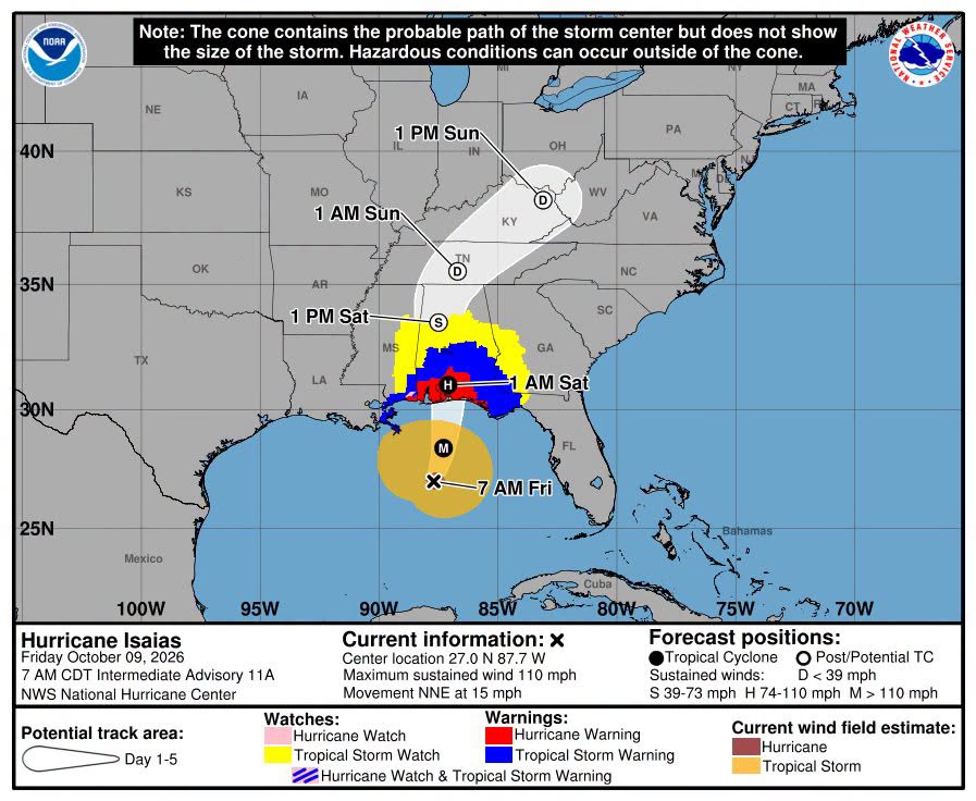
SHREVEPORT, La. — Hurricane Isaias strengthened into a major Category 3 hurricane Friday morning as the storm moved toward the northern Gulf Coast, where forecasters expect it to make landfall late Friday or early Saturday.
The National Hurricane Center said at 7:20 a.m. CDT that an Air Force Reserve Hurricane Hunter aircraft measured maximum sustained winds of 120 mph as Isaias continued moving north-northeast through the Gulf.
The storm was located about 240 miles south of Pensacola, Florida, and about 170 miles south-southeast of the mouth of the Mississippi River. Isaias was moving north-northeast at 15 mph.
While the hurricane has intensified rapidly, Northwest Louisiana is expected to remain well outside the storm’s primary impact area.
The National Hurricane Center’s forecast takes the storm toward the Alabama-Florida Panhandle portion of the Gulf Coast. Hurricane warnings extend from Ocean Springs, Mississippi, to the Bay/Gulf County line in Florida, while a tropical storm warning extends westward into extreme southeast Louisiana.
A storm surge warning is in effect from the mouth of the Mississippi River eastward to the Suwannee River in Florida.
Forecasters said Isaias is expected to approach the northern Gulf Coast Friday afternoon and make landfall Friday night or early Saturday. Some weakening is possible before the center reaches land, but the hurricane is expected to remain dangerous at landfall.
Hurricane-force winds extend outward up to 30 miles from the center, while tropical-storm-force winds extend as far as 185 miles.
The storm poses a threat of life-threatening storm surge, damaging winds and heavy rainfall along portions of the central and eastern Gulf Coast. Florida and Alabama have declared states of emergency, and evacuations have been ordered in some coastal areas.
In Northwest Louisiana, Isaias is expected to have nearly the opposite effect.
The National Weather Service in Shreveport said the hurricane will remain well east of the Ark-La-Tex. Dry conditions and northeast winds gusting as high as 25 mph are expected Friday, creating favorable conditions for wildfires. A Red Flag Warning is in effect for portions of the region.
Entergy Louisiana began preparing earlier this week for possible impacts from Isaias, saying crews were ready to respond to severe weather affecting its service territory once conditions allowed.
Isaias is the first hurricane of the 2026 Atlantic hurricane season.
The National Hurricane Center is expected to continue issuing updates throughout Friday as Isaias approaches the coast.